Science
Hurricane Erin Strengthens to Category 5, Historic Intensification Recorded

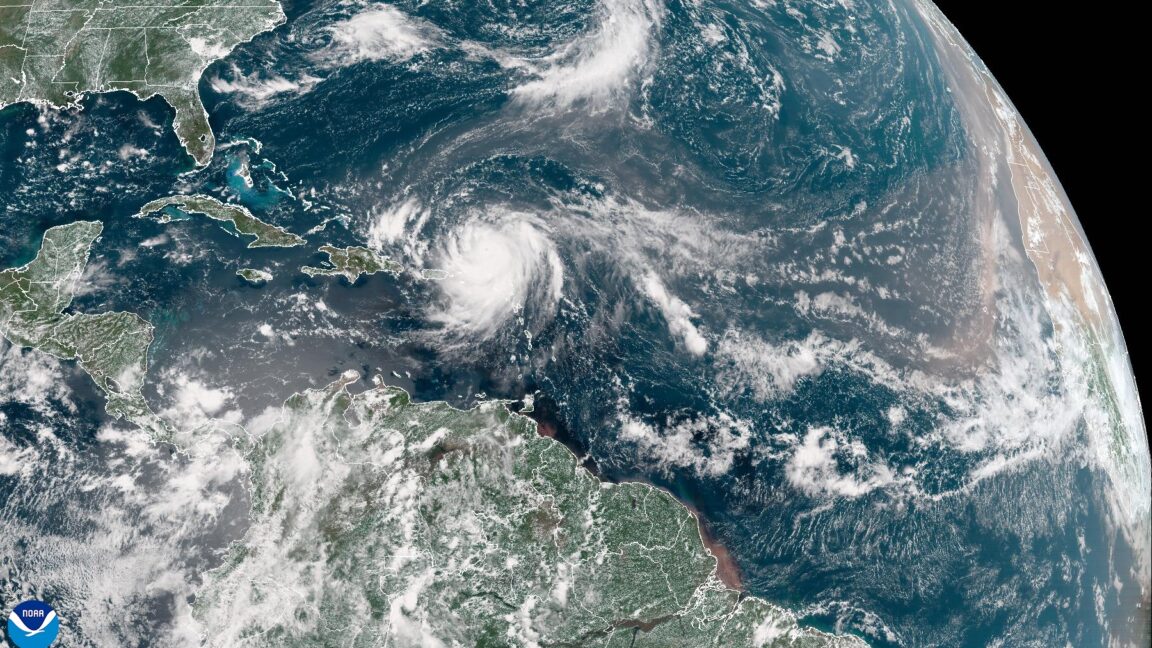
Hurricane Erin has rapidly intensified into a Category 5 storm, marking a historic milestone as it became the most powerful hurricane recorded before September 1. The National Hurricane Center announced this classification shortly before noon on Saturday, with sustained winds reaching 160 mph, as measured by a US Air Force Hurricane Hunter aircraft.
Erin’s trajectory is expected to take it north of the Caribbean islands before veering towards the Bahamas and the Eastern United States. Forecasters believe the storm will maintain a safe distance from land, potentially minimizing catastrophic damage. It is projected to pass between Atlantic Canada and Bermuda later next week, with reliable models supporting this forecast.
Historic Rapid Intensification
The storm’s rapid intensification is noteworthy. Erin was classified as a hurricane only at 11 am ET on Friday while moving north of the Leeward Islands. Since then, it has deepened by an astonishing 70 millibars in just 24 hours, according to meteorologist Sam Lillo. This significant pressure drop places Erin as the most rapidly intensifying hurricane recorded in the Atlantic before September, surpassing previous records.
With a central pressure of 917 mb, Erin is now the second-most intense Atlantic hurricane in the last 50 years prior to this date, only trailing behind Hurricane Allen, which occurred in 1980. Such rapid intensification raises concerns, as storms of this nature are predicted to become more common in the future due to climate change.
Climate Change and Future Storm Trends
Research indicates that the frequency of intense storms like Erin may increase as global temperatures rise. A study published in *Nature Communications* found that the 24-hour intensification rates for the strongest 5 percent of Atlantic hurricanes increased by approximately 3–4 mph per decade from 1982 to 2009. The authors concluded that there is a detectable increase in Atlantic intensification rates linked to human activities.
The US government’s Climate.gov website supports this finding, stating that the proportion of severe tropical cyclones, classified as Category 4 and 5, has risen. This trend is expected to continue, leading to storms with more damaging winds, higher storm surges, and increased rainfall rates. Most climate model projections suggest a decrease in the number of low-intensity cyclones, which may mean that while the total number of tropical cyclones each year remains stable, the intensity of those storms is likely to rise.
Despite the overall lower activity in the tropical Atlantic this year, Erin’s longevity and intensity could soon bring the season’s total activity to normal levels, as measured by Accumulated Cyclone Energy. Traditionally, the Atlantic hurricane season peaks in early September, with the majority of storms forming between early August and early October. Forecast models indicate the potential development of additional hurricanes in the coming weeks, although whether they will make landfall remains uncertain.
As Hurricane Erin continues its path across the Atlantic, the focus remains on monitoring its impact on coastal regions and the potential implications for future storm patterns in the context of a changing climate.
-

 Lifestyle3 months ago
Libraries Challenge Rising E-Book Costs Amid Growing Demand
-

 Sports3 months ago
Tyreek Hill Responds to Tua Tagovailoa’s Comments on Team Dynamics
-

 Sports3 months ago
Liverpool Secures Agreement to Sign Young Striker Will Wright
-

 Lifestyle3 months ago
Save Your Split Tomatoes: Expert Tips for Gardeners
-

 Lifestyle3 months ago
Princess Beatrice’s Daughter Athena Joins Siblings at London Parade
-

 World3 months ago
Winter Storms Lash New South Wales with Snow, Flood Risks
-

 Science3 months ago
Trump Administration Moves to Repeal Key Climate Regulation
-

 Science2 months ago
San Francisco Hosts Unique Contest to Identify “Performative Males”
-

 Business3 months ago
SoFi Technologies Shares Slip 2% Following Insider Stock Sale
-

 Science3 months ago
New Tool Reveals Link Between Horse Coat Condition and Parasites
-

 Sports3 months ago
Elon Musk Sculpture Travels From Utah to Yosemite National Park
-

 Science3 months ago
New Study Confirms Humans Transported Stonehenge Bluestones


