
World
Winter Storms Lash New South Wales with Snow, Flood Risks
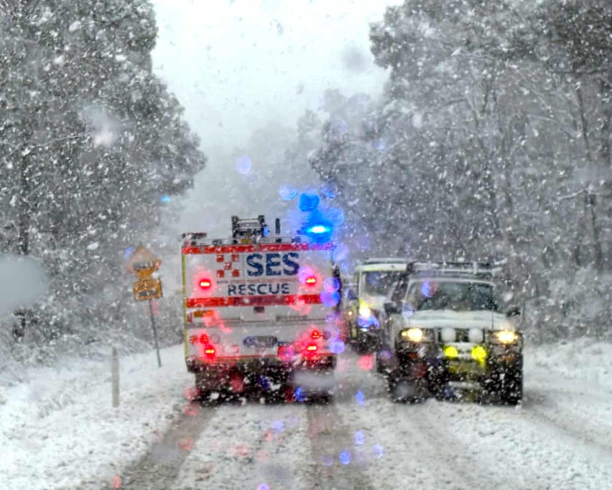
Severe winter storms are currently impacting New South Wales (NSW), bringing heavy snowfall to the northern tablelands and relentless rain to other parts of the state. As of Saturday afternoon, the NSW State Emergency Service (SES) had issued 28 warnings across regions including the Coffs Coast, Mid North Coast, Upper Hunter, and New England.
The SES forecasts that 24-hour rainfall totals could reach between 65 mm and 100 mm, with isolated areas experiencing over 130 mm. Assistant Commissioner Nicole Hogan warned that the persistent rain poses a significant risk of flooding on local roads, potentially rendering them impassable.
“We’ve had crews in Tamworth doorknocking low-lying areas to alert locals of potential localized flash flooding and road closures overnight,” Hogan stated. She emphasized the importance of safety, urging the community to avoid flooded areas. “If you come across a flooded road, turn around and find an alternative route.”
The heavy rainfall has already resulted in rising river levels, with moderate flooding reported along the Peel River in Tamworth and the Namoi River in Gunnedah. Additionally, unusual snowfall levels have been recorded in Armidale and Guyra, with snow accumulations of up to 50 cm expected throughout Saturday.
As conditions worsen, the risk of black ice has emerged as a significant concern, leading to hazardous road conditions across the northern tablelands. “We have road crash crews prepositioned and ready to respond to any rescues, but we ask the community to please avoid unnecessary travel,” Hogan added. For those who must drive in snowy regions, she recommended exercising caution: “Always use your brakes gently and drive slowly.”
In addition to the snow and rain, damaging wind gusts exceeding 90 km/h and large surf conditions are forecasted. Over 1,000 volunteers from the NSW SES have been mobilized across the state, responding to approximately 750 calls for assistance since the onset of the severe weather.
The SES continues to monitor the situation closely and will provide updates as conditions develop. Residents are encouraged to stay informed and prioritize safety during this challenging weather event.

Knowles CEO Jeffrey Niew Divests Shares Worth Nearly $2 Million

Echo Financial Expands Advisory Services to Higher Education Sector

Luc Besson’s ‘Dracula’ Reimagines Classic Tale as Romantic Drama

Citigroup Lowers IQVIA Price Target to $200, Analysts Respond

Discover Detroit: A Walking Tour Through Its Rich History

Study Reveals Off-Pump CABG Reduces Perioperative Risks

NY Pie Expands with New Location in Nashville’s Capitol View

Rogers Communication vs. PT Telekomunikasi: A Comparative Analysis

Researchers Uncover Genetic Links to Parkinson’s Disease Risk

Libraries Challenge Rising E-Book Costs Amid Growing Demand

Tyreek Hill Responds to Tua Tagovailoa’s Comments on Team Dynamics

Liverpool Secures Agreement to Sign Young Striker Will Wright

Save Your Split Tomatoes: Expert Tips for Gardeners

San Francisco Hosts Unique Contest to Identify “Performative Males”

Princess Beatrice’s Daughter Athena Joins Siblings at London Parade

Elon Musk Sculpture Travels From Utah to Yosemite National Park

Winter Storms Lash New South Wales with Snow, Flood Risks

Trump Administration Moves to Repeal Key Climate Regulation
-
 Lifestyle7 months ago
Libraries Challenge Rising E-Book Costs Amid Growing Demand
-
 Sports6 months ago
Tyreek Hill Responds to Tua Tagovailoa’s Comments on Team Dynamics
-
 Sports6 months ago
Liverpool Secures Agreement to Sign Young Striker Will Wright
-
 Lifestyle6 months ago
Save Your Split Tomatoes: Expert Tips for Gardeners
-
 Science6 months ago
San Francisco Hosts Unique Contest to Identify “Performative Males”
-
 Lifestyle6 months ago
Princess Beatrice’s Daughter Athena Joins Siblings at London Parade
-
 Sports7 months ago
Elon Musk Sculpture Travels From Utah to Yosemite National Park
-
 Science7 months ago
Trump Administration Moves to Repeal Key Climate Regulation
-

 Business7 months ago
SoFi Technologies Shares Slip 2% Following Insider Stock Sale
-

 Science7 months ago
New Tool Reveals Link Between Horse Coat Condition and Parasites
-

 Sports6 months ago
Bubba Wallace Makes History with Brickyard 400 Victory
-

 Science6 months ago
California Develops New Method to Monitor Toxic Algal Blooms