
World
Severe Weather Hits New South Wales: Tornado Warning Downgraded
A severe weather system has triggered numerous emergency responses across New South Wales, with incidents of flooding and a tornado warning affecting communities in the region. Over the past 24 hours, the NSW State Emergency Service has dealt with more than 90 incidents, including dramatic rescues involving a motorist who drove off a cliff at the Camden Bypass and a group of bushwalkers stranded by rising waters in Wattamolla.
Communities along the Illawarra and South Coast, including Wollongong, Goulburn, Nowra, and Bowral, have been warned to prepare for intense rainfall and strong winds. Forecasts predict rainfall totals could reach up to 100 mm every six hours as a low-pressure system moves through the state, raising concerns of flash flooding and minor river rises.
Weather Developments and Safety Warnings
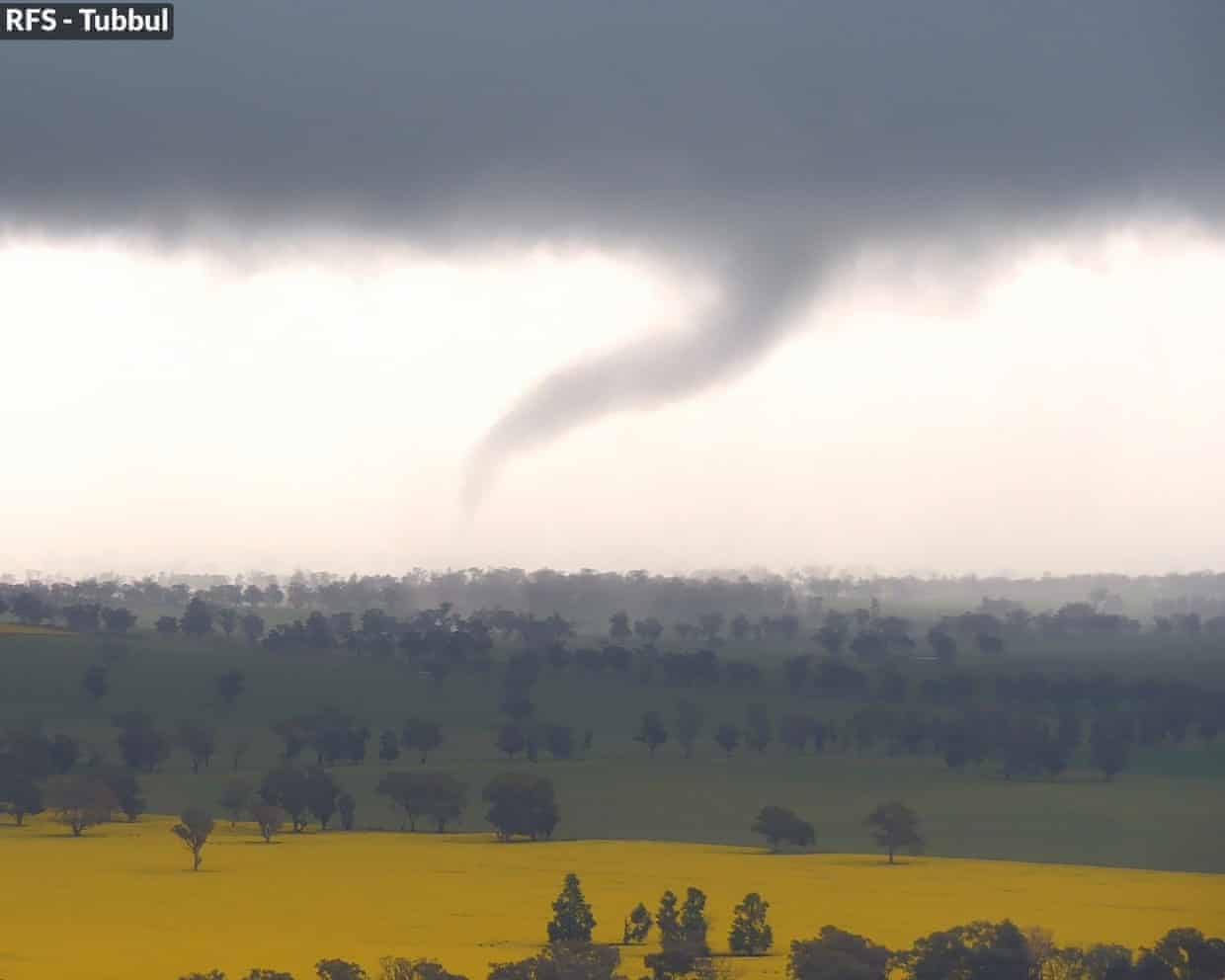
A tornado was observed northwest of Young at approximately 15:30 local time, according to the Bureau of Meteorology, but the warning was subsequently downgraded. As the weather system continues to progress, Dean Storey, assistant commissioner of the NSW SES, emphasized the risks associated with floodwaters, stating, “Flash flooding can occur quickly and without warning. We implore motorists to never drive, walk or ride through floodwaters.”
Severe thunderstorms are expected to develop across large parts of New South Wales, including the Hunter and Central Tablelands, on Wednesday evening. These conditions may persist as the system moves over the Tasman Sea on Thursday. Wind gusts may reach up to 125 km/h, accompanied by large hail ranging from 2 to 4 cm.
Impacts and Ongoing Alerts
In the last day, eastern New South Wales has faced significant lightning, rain, and showers, with further severe thunderstorms anticipated. Senior meteorologist Miriam Bradbury warned that the low-pressure system will pull in substantial moisture and winds, increasing the risk of severe weather into the early hours of the next day.
Currently, five minor flood warnings are in effect for the Darling, Macquarie, Bogan, Orange, Upper Hunter, Hawkesbury Nepean Valley, and St Georges Basin catchments. These conditions could lead to local road and bridge closures. Additionally, a hazardous surf and strong wind warning has been issued for significant portions of the coastline, including Sydney.
As the storm system continues its path, conditions along the coast are expected to remain windy and showery on Thursday, while inland areas may begin to dry out after a particularly wet period. In Sydney, temperatures are forecast to reach 18 degrees Celsius, with ongoing rainfall impacting both coastal and inland regions.

DraftKings Offers New Users $200 Bonus Bets and NFL Ticket Discount

Discover Top Game Pass Titles for This Weekend (Sept. 19-21, 2025)
Sambo Ly Receives Icon Award for Lifelong Community Service

Lauritzen Gardens’ Conservatory Reopens After $11.3 Million Upgrade

Ted Cruz Criticizes FCC Chair’s Threats Against Broadcasters

Jimmy Kimmel’s Show Cancellation Sparks Global Media Concerns

Inter Miami Aims to Climb East Standings Against D.C. United

IDF Engages Hamas in Gaza City, Ten Militants Killed

Understanding Your Dog’s Barks: Insights from Pasadena Humane

Libraries Challenge Rising E-Book Costs Amid Growing Demand

Tyreek Hill Responds to Tua Tagovailoa’s Comments on Team Dynamics

Liverpool Secures Agreement to Sign Young Striker Will Wright

Save Your Split Tomatoes: Expert Tips for Gardeners

Princess Beatrice’s Daughter Athena Joins Siblings at London Parade

Winter Storms Lash New South Wales with Snow, Flood Risks

Trump Administration Moves to Repeal Key Climate Regulation

SoFi Technologies Shares Slip 2% Following Insider Stock Sale

New Tool Reveals Link Between Horse Coat Condition and Parasites
-
 Lifestyle2 months ago
Libraries Challenge Rising E-Book Costs Amid Growing Demand
-
 Sports2 months ago
Tyreek Hill Responds to Tua Tagovailoa’s Comments on Team Dynamics
-
 Sports2 months ago
Liverpool Secures Agreement to Sign Young Striker Will Wright
-
 Lifestyle2 months ago
Save Your Split Tomatoes: Expert Tips for Gardeners
-
 Lifestyle2 months ago
Princess Beatrice’s Daughter Athena Joins Siblings at London Parade
-
 World2 months ago
Winter Storms Lash New South Wales with Snow, Flood Risks
-
 Science2 months ago
Trump Administration Moves to Repeal Key Climate Regulation
-
 Business2 months ago
SoFi Technologies Shares Slip 2% Following Insider Stock Sale
-
 Science2 months ago
New Tool Reveals Link Between Horse Coat Condition and Parasites
-

 Science4 weeks ago
San Francisco Hosts Unique Contest to Identify “Performative Males”
-

 Science2 months ago
New Study Confirms Humans Transported Stonehenge Bluestones
-

 Science2 months ago
Tom Lehrer, Pioneering Satirist and Musician, Dies at 97