
Science
Carnegie Mellon and Meta Develop Groundbreaking 3D Mapping Model
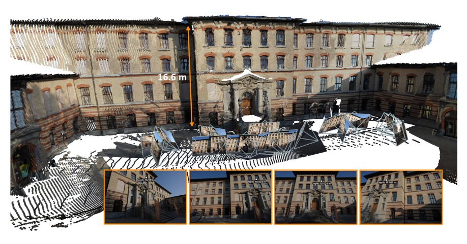
Researchers from Carnegie Mellon University’s Robotics Institute and Meta Reality Labs have developed a new model that enables robots to create detailed 3D maps from various data sources. Named MapAnything, this innovative technology enhances the ability of robots to navigate complex environments with greater accuracy and efficiency.
Advancing Robotic Spatial Reasoning
The MapAnything model represents a significant leap forward in robotic perception, allowing machines to interpret camera data and depth scans as coherent 3D structures. This development is crucial for improving how robots understand their surroundings, particularly in cluttered or dynamic settings.
According to Nikhil Keetha, a Ph.D. student at the Robotics Institute and co-lead researcher on the project, “When humans interact with the world, we constantly estimate distances—how far away something is, whether we will run into it, or how far we need to reach out to grasp it.” He further explained that traditional 2D images limit robots’ abilities to perform similar spatial reasoning. The introduction of MapAnything marks a foundational step toward equipping machines with a more humanlike comprehension of their environments.
Large-Scale Data Sets Enhance Precision
To train the MapAnything model, the research team compiled an extensive dataset, encompassing over 200,000 real-world scenes. This dataset includes a variety of environments, such as classrooms, offices, outdoor paths, and forests. The model’s flexibility was evident during testing, demonstrating high performance across different scenarios.
Keetha noted, “We wanted to enable 3D metric scene geometry in a very flexible way. Current systems are either slow or only support a particular task. With MapAnything, we can handle any number of images or data types and build accurate 3D maps in one step.” This capability means that the model can reconstruct anything from a small water bottle on a desk to an entire office layout seamlessly.
The implications of this technology extend beyond robotics. Applications could include enhanced augmented reality experiences and improved environmental mapping, providing valuable tools for various industries.
For further information on MapAnything, interested parties can visit the project website. Media inquiries can be directed to Aaron Aupperlee at 412-268-9068 or via email at [email protected].

New Jersey Risks Economic Growth by Neglecting Veteran Entrepreneurs

Fans Demand Canon for Top 20 Unofficial TV Couples
Study Reveals Promising Outcomes for Mismatched Blood Transplants

WJXT Secures Four Suncoast Emmys for Cultural Excellence

$1.25 Million Grant Fuels Hawaiʻi’s Advanced Hazard Monitoring Initiative

DraftKings Launches Exciting $300 Bonus for Missouri Sports Bettors

Dark Humor and Thrills Unfold in ‘Caught Stealing’ Adaptation

Long Butterfly Cut with Bangs Takes the Hair Trend Spotlight

László Krasznahorkai Engages Audience with Rare Lecture in Stockholm

Libraries Challenge Rising E-Book Costs Amid Growing Demand

Tyreek Hill Responds to Tua Tagovailoa’s Comments on Team Dynamics

Liverpool Secures Agreement to Sign Young Striker Will Wright

Save Your Split Tomatoes: Expert Tips for Gardeners

Princess Beatrice’s Daughter Athena Joins Siblings at London Parade

San Francisco Hosts Unique Contest to Identify “Performative Males”

Winter Storms Lash New South Wales with Snow, Flood Risks

Trump Administration Moves to Repeal Key Climate Regulation

SoFi Technologies Shares Slip 2% Following Insider Stock Sale
-
 Lifestyle5 months ago
Libraries Challenge Rising E-Book Costs Amid Growing Demand
-
 Sports4 months ago
Tyreek Hill Responds to Tua Tagovailoa’s Comments on Team Dynamics
-
 Sports4 months ago
Liverpool Secures Agreement to Sign Young Striker Will Wright
-
 Lifestyle4 months ago
Save Your Split Tomatoes: Expert Tips for Gardeners
-
 Lifestyle4 months ago
Princess Beatrice’s Daughter Athena Joins Siblings at London Parade
-
 Science4 months ago
San Francisco Hosts Unique Contest to Identify “Performative Males”
-
 World4 months ago
Winter Storms Lash New South Wales with Snow, Flood Risks
-
 Science5 months ago
Trump Administration Moves to Repeal Key Climate Regulation
-
 Business5 months ago
SoFi Technologies Shares Slip 2% Following Insider Stock Sale
-

 Science5 months ago
New Tool Reveals Link Between Horse Coat Condition and Parasites
-

 Sports5 months ago
Elon Musk Sculpture Travels From Utah to Yosemite National Park
-

 Science5 months ago
New Study Confirms Humans Transported Stonehenge Bluestones